Emily Peak
- Mike Morelli

- Mar 9, 2025
- 3 min read
Updated: May 28
Date: March 10, 2025
Location: Ailsa Mountains, Mount Aspiring National Park, Glenorchy, Otago, New Zealand
Team: Alex Catalfamo
Field Notes: Take the Routeburn Track towards Flats. At the junction with the hut, take the trail up towards Falls Hut. At the third bridge, walk underneath the bridge and head into the stream bed. The stream immediately splits, take the branch to the climbers right. The stream bed offers easy travel, although would best be avoided after heavy rainfall and is probably best climbed in summer or autumn. At 1,200 meters, leave the stream and climb through tussock angling towards Emily Pass. Head into the gut, taking care with loose rock, angling up and around to Emily Pass. To access the South West Face, drop down at least 100 meters and sidle around the mountain. At the base of the face, easy slabs lead up to the summit. Difficulties are easily surpassed by finding a ledge or alternative.

Alex and I have been on a tear since he arrived in New Zealand. Week after week of good weather has seen us up many of the local peaks.
Incredibly, Alex stepped on a bee just a few days before the trip and his foot swelled up like a balloon. We had plans to go do Cleft Peak over two days but thought it was better to have another rest day.
We woke up on Monday morning and hit the road early. The temperature was cool and we almost put gloves on. The trail was quiet. Just a few hikers were making their way back to their cars to finish the Great Walk.

At the Falls Hut junction, we started uphill and got to our bridge in fifteen minutes. At least I thought it was the right bridge. Turns out it was the third bridge we were after. I realized this just a bit too late.
Instead of simply backtracking, I took us on a fifteen-minute scrub bash. Alex wasn't happy. Sorry mate!
Back in the correct creek branch, we made fast travel up through the stream bed. At 1,200 meters we climbed out of the creek, onto a spur, and followed a cairned route East in a basin. In hindsight, this isn't necessary. A more direct route would be to climb out of the creek at 1,200 meters and head directly South for Emily Pass.


To access the pass, we headed into the obvious gut which heads up and wraps around to the Southwest. We found it to be wet with loose rock and care should be taken.
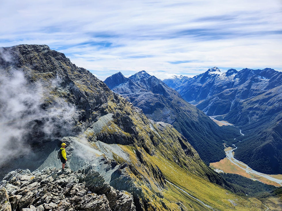
Finally, at the top of the pass, we dropped down about one hundred meters and wrapped around the peak to access the South West Face.
Alex's ankle was bothering him at this point and I was slightly concerned on how he'd go on the steeper face. We took our time looking for the best route up the mountain and picked our way up the face. Determined, Alex powered on.

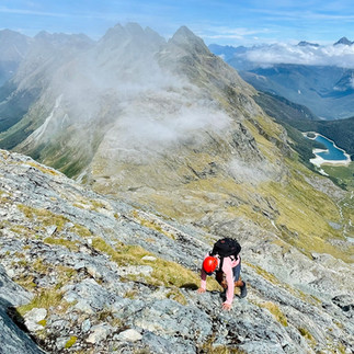


As we climbed higher, the views became dramatic. Lush green valleys split by a blue flowing river. Spiky mountain top peaks against a cobalt sky.
At six hours since leaving the car we stood on the summit. Somnus, The God of Sleep, stood high above the North Routeburn. Although the mountains in this region are not as high as the other peaks in the region, the views are out of this world.
After a good lunch, we started down and made light work of the descent. I kept thinking of how this face would ski with snow on it.
We sidled over annoying terrain at the bottom of the face and made the climb back up to Emily Pass.
The rest of the day was as expected: a long grind down through Emily Pass, back across slippery tussock, down a creek, and eventually a few hours along the Routeburn Track. Alex's ankle was fully pissed off and after almost twelve hours we were both stoked to be off our feet.
Another classic memory with 'Talf!
Happy days...


Comments